Join us on the journey

"two roads diverged in a wood, and I -- I took the one less traveled by, And that has made all the difference." -- Robert Frost

Friday, March 1, 2013

Day Trip: Anchorage to Homer


Distance and time: about 222 miles/4 hours

Homer, Alaska, famous for its spit of land that reaches out into Kachemak Bay, is also noteworthy for its tides and strong tidal currents. The wide range—average of 15 feet and differential between very high and very low tide of 28 feet—contributes to the rich estuary and salt marshes. Homer lies at the end of the road from Anchorage, a 226 mile scenic Sterling Highway drive.

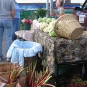
There is a special place on the spit known as the Fishing Hole, a lagoon where children and others who aren’t up to the rigors of ocean fishing can cast and take an opportunity to catch fish.

Exhibits and presentations really drive home the concept that one big ocean--in the best of all worlds a healthy ocean--links all living things on earth.

Homer, Alaska is all about fishing
Ninilchik
The town of Ninilchik was settled in the 1800s by Russian fur traders. The town of fewer than 900 people has preserved its Russian heritage in a most picturesque way. 

Might those be eagles in flight above the church yard? 

The Russian Orthodox Church, Holy Transfiguration of Our Lord Chapel, sits on a hilltop overlooking the sea and shore below. It was constructed at the location where it now stands in 1901, its cemetery marked with simple white Russian crosses. 

Summer brings a blaze of flowers to the Russian church yard
Volcano Sightings


Weather permitting, the drive from Anchorage to Homer presents some spectacular volcano viewing opportunities as you gaze across the Cook Inlet. 

The closest to Anchorage is Mount Spurr. It stands 11,070 feet high and last erupted in 1992. 

Following and across from the town of Soldotna is Mount Redoubt at 10,197 feet. It erupted in 2009 on March 22, dusting the region with abrasive volcanic ash. No stranger to activity, Redoubt has had five eruptions since 1900, including one 1989. 

As you continue on south toward Homer, next in the series is Mount Iliamna at 10,016  feet. The last in this mini ring of fire is Augustine Volcano, only 4025 feet south of Homer and out on an island. 


Thursday, February 14, 2013

Day Trip: Anchorage to Seward


Distance and time: about 127 miles/2 hours 40 minutes

Western Columbine, Kenai Fjords National Park
South of Anchorage, the Seward Highway, a designated All-American Road, leads to Seward, Alaska. 
Seward, Alaska small boat harbor

St. Peter's Episcopal Church 

The historic church, the first Protestant church established on the Kenai Peninsula, is at 239 2nd Avenue on the corner of Adams Street in Seward, Alaska. 

The year 1904 marked the first services in Seward held in by an Episcopal priest from Valdez. Construction on the building itself took place between 1905 and 1906. Consecration was conducted by the first bishop of the Episcopal Diocese of Alaska, Rt. Rev. Peter Trimble Rowe, on April 1, 1906. 

In 1924, the Dutch artist Jan Van Emple came to Seward for an extended visit, and during the following year he undertook a sacred work of art, “The Resurrection,” inside the church behind the altar. Known as a reredos, the mural is a uniquely Alaskan depiction of the Resurrection and Ascension of Christ. 
St. Peter's Episcopal Church, Seward, Alaska

Instead of the more expected and traditional appearing apostles, the painting depicts people of Alaska including, as the Seward Historic Preservation Commission describes, "Eskimos, a trapper, a fisherman and a pioneer woman make up the foreground. The little Indian mother is unable to lift her head to up to heaven with the rest because her baby weighs so heavily upon her back."


One view of Resurrection Bay, Seward, Alaska
Another view of Resurrection Bay
Cruise ships regularly dock at Seward, Alaska
Alaska Sealife Center
Question: How much cold, fresh sea water does it take to keep Alaska’s salt water aquarium fresh and friendly? 
Answer: about 4,500 gallons per minute. Visitors to the Alaska Sealife Center are treated to Stellar sea lions, seals, puffins and other sea birds and representatives of other arctic flora and fauna. It is Alaska’s only permanent marine mammal rehabilitation center, and is also a marine research and education facility. 
A puffin paddles for onlookers at the Alaska Sealife Aquarium

Exit Glacier
Exit Glacier, in Kenai Fjords National Park, is one of Alaska’s most accessible glaciers. It is an easy half-mile walk from the visitor’s center.
Exit Glacier near Seward, Alaska


Friday, February 8, 2013

Whittier, Alaska continued

Images of Whittier

Water is the industry and recreation of Whittier
Photo with thanks to Bobbi-Lynn Palmer


Winter residents of Whittier live in one building
Photo with thanks to Bobbi-Lynn Palmer


Whittier is a major cruise ship port
Photo with thanks to Bobbi-Lynn Palmer


Photo with thanks to Bobbi-Lynn Palmer

Photo with thanks to Bobbi-Lynn Palmer


Monday, February 4, 2013

Day Trip: Anchorage to Whittier


Distance and time: about 61 miles/at least 1 hour 30 minutes

Whittier is both a town of fewer than 300 people and an ice free port about 60 miles and one very long tunnel south of Anchorage. 

Whittier is a busy port for cruises and excursions
Cruise ships make Whittier on Prince William Sound a port of call, and it also supports all kinds of travel, recreation and commercial enterprise including the Alaska State Ferry, commercial fishing, the Alaska Railroad, freight barge service, a small boat harbor, and other recreation and tourism such as sea kayaking. While the town is small, with most people living in one building during winter, it handles visitors that number about 700,000 each year.

Weather is frequently wet, with the 20 feet of annual snowfall interrupted by about 15 feet of rain per year. In winter, the temperature range is from about 17 to 28 degrees. Summer average temperatures are usually from about 49 to 63 degrees.

The magnitude of Prince William Sound, like so much of Alaska, is hard to comprehend. It covers 2,100 square miles, with fjords reaching like long fingers and islands dotting the landscape. The area exceeds the size of all of Vermont in the lower 48. There is no other intact marine ecosystem in America that is larger. It is a rain forest, the northern-most one in all of North America.

Alaska’s glaciers fall into three categories:

  • Alpine or hanging glaciers are ice masses that form high on mountain slopes
  • Piedmont glaciers originate as glacial ice fans out at the foot or base of mountains
  • Tidewater glaciers, like rivers of ice, are under pressure from their own weight as they move toward the ocean. Where ice meets water, great chunks or slabs of tidewater glacier ice will break away and crash with tremendous force, a process called calving. The results of calving are icebergs.

Cruises out of Whittier are popular for glacier viewing, since so many can be seen in a single day outing.

http://www.whittieralaska.gov/

Getting to Whittier
The Anton Anderson Memorial Tunnel is often called the Portage tunnel or the Whittier tunnel by Alaskans. The tunnel wends through Maynard Mountain and connects the Seward Highway south of Anchorage with Whittier. In fact, it provides the only land access to Whittier. It is 13,300 feet long (4,050 meters). That makes it North America’s longest combined highway and rail tunnel in North America and second longest highway tunnel.

It is a controlled single lane tunnel with alternating vehicle and train use. Vehicles are required to wait in a staging area at each end of the tunnel until the fifteen minute interval elapses before the next scheduled departure in summer. During freezing temperatures and fixed winter openings, schedules are different.


There are vehicle size limits:
http://www.dot.state.ak.us/creg/whittiertunnel/vehiclesize.shtml

There are also schedule limits. Locals remind visitors to be sure to exit Whittier before the tunnel closes at night. If you are caught on the Whittier side, you become a POW, prisoner of Whittier, for the night.


Thursday, January 31, 2013

Day Trip: Anchorage to Portage Glacier

Distance and time: about 60 miles/1 hour 30 minutes

Portage Glacier and Portage Lake
The Kenai Peninsula, were it not for a 14 mile isthmus, Portage Valley, would be an island. As it stands, a small ribbon of land connects the Kenai to mainland Alaska.

Long ago, Portage Glacier extended through the length of the valley. Some glacial remnants are visible such as Burns, Byron, Explorer, Middle and Shakespeare glaciers. These glaciers, massive and awe inspiring in their current state, are only vestiges of the ice sheets that used to cover the Portage Valley landscape.
Portage Glacier view

There are plenty of public campgrounds that can accommodate tents and RVs in the Portage Glacier region.

Begich, Boggs Visitor Center
Within sight of Portage Glacier, the Begich, Boggs Visitor Center stands, built on the glacier’s terminal moraine. A U.S. federal installation, the Visitor Center offers award-winning exhibits, an Alaska Geographic bookstore, educational opportunities and a film.

Catch these links to local information: 

Byron Glacier trail is easily accessible near Portage Lake


Portage Glacier Cruises and Tours
You can catch a Portage Glacier cruise at Portage Lake.  Parking is available adjacent to the dock. A number of tour companies will also provide transportation to and from Anchorage.

Here is just one link to an available source:

A view of Byron Glacier near Portage Lake

Saturday, January 26, 2013

In and around Anchorage: Alaska Public Lands Information Center


The Alaska Public Lands Information Center is housed in a U.S. federal building. We appreciated knowing that in advance of our visit, since we needed to present a passport or other federal identification. We also passed through a security gate, emptied pockets and opened purse for a cursory search.

The Information Center helps visitors
learn about Alaska wildlife; Photo provided
by Visit Anchorage
The Information Center shows films, provides maps, hosts natural history exhibits, and is staffed with knowledgeable uniformed rangers who answer questions and provide presentations. It is located at 605 W. Fourth Ave. in downtown Anchorage. There is no charge for entry. 

Click here details:

Friday, January 25, 2013

In and around Anchorage—Earthquake Park, Point Woronzof, and Tony Knowles Coastal Trail

Moose abound in Anchorage;
Photo provided by Visit Anchorage

Earthquake Park is located not far from Anchorage International Airport. The park provides an expansive walking and bicycling trail. On a day with great visibility, you can catch a wide panorama that includes Sleeping Lady, aka Mount Susitna, that lies across the Cook Inlet from Anchorage. 

You can also see the Alaska Range and even Denali, known outside of Alaska as Mount McKinley. 

The Park, on West Northern Lights Boulevard near Aircraft Drive, is fee-free and open daily. The trail system is dotted with interpretative signs to help you understand how the landscape was formed. It connects with the Tony Knowles Coastal Trail. Visitors should be advised that the park is frequently visited by wildlife, with moose sightings particularly common.

Anchorage skyline; photo provided by Visit Anchorage
The area where Earthquake Park now stands was once covered in homes. In 1964, when a 9.2 earthquake struck on Good Friday, more than 70 of the homes toppled into the Cook Inlet. The earthquake, North America’s largest recorded one, left $68 million in damages in its wake.

The airport strives to keep to moose off runways with high fences. When moose encounter the no-way-in fences, they tend to congregate. As a result, the area of the Trail adjacent to Point Woronzof can be wonderful for moose viewing from inside a vehicle. Keep a civil distance between you and moose.

Bicyclists photo provided by
Visit Anchorage
If you like to walk, jog or bicycle, the Tony Knowles Coastal Trail offers a great opportunity to see Anchorage from the coastal perspective. The Trail follows the edge of the Knik Arm of the Cook Inlet and provides a number of logical places to start and stop explorations from Elderberry Park in the downtown area, to Westchester Lagoon or all the way to Earthquake Park. 


Thursday, January 24, 2013

In and around Anchorage—Arctic Valley


Distance and Time: about 14 miles/30 minutes

Arctic Valley may be better known with Anchorage locals than with visitors.

A small stream atop Arctic Valley... the origin of Ship Creek? 
As we drove into Arctic Valley, we entered Moose Run Golf Course. This military course is open to civilians including visitors from far and wide. Together, Moose Run’s Hill and Creek Courses are known as “the world's northernmost 36-hole golf course.”

Wild geranium, one of many wildflowers in Arctic Valley
As the elevation increased on Arctic Valley Road, the driving became a bit steeper and more challenging. This area east of and high above Anchorage’s downtown invites visitors to hike, watch birds and other wildlife, see wildflowers and in the summer pick berries. At the top near the Arctic Valley Ski Area, set among a thicket of trees, we found a wellspring of water we were told is the origin of Ship Creek.

The valley is accessible from Arctic Valley Road, a little more than a 20 minute drive from Anchorage. From downtown Anchorage, take the Glenn Highway east toward Eagle River. Take the first exit for Arctic Valley and follow the road to the ski area.

For more information:


Tuesday, January 22, 2013

In and around Anchorage: Lake Hood

Photography provided by Visit Anchorage

Lake Hood is the world’s busiest float plane lake. It handles about 190 flights every day. It is located about three miles from the Anchorage downtown center, off Lake Hood Drive and just north of Ted Stevens Anchorage International Airport. 

Thursday, January 17, 2013

In and around Anchorage: off-leash dog & other parks


In our quest for dog parks in Anchorage, we found the off-leash area at Russian Jack Springs Park most favorable. The huge open meadow off Pine Street provided ample room for our large, energetic dog to run. Another park our dog appreciated was at Jewel Lake, just north of West Dimond Blvd. (yes, Dimond is the correct spelling) and west of West 88th Avenue. The lake was not excessively cold in summer and our dog loves to swim and retrieve.

When we read about other dog parks in Anchorage, we found Far North Bicentennial Park mentioned, along with the park adjacent to University Lake near the University of Alaska campus off Elmore Road. We were never able to locate the off-leash area at Far North Bicentennial Park, and we heard from another dog owner that during their visit, the beavers at University Lake had been aggressive toward dogs. 

Try these links for more information: 


All dogs, especially camping dogs, need  a place to run

Wednesday, January 16, 2013

Day Trip: Anchorage to Alaska Wildlife Conservation Center


Distance and time: about 49 miles/1 hour

Adults and kids can see moose safely up close at the AWCC
The Alaska Wildlife Conservation Center (AWCC) takes in injured and orphaned animals—more than 150 of them summer 2012—that are not be able released to the wild. The AWCC works with other facilities throughout the U.S. to place animals. Many live out their lives at AWCC.
A grizzly bear that cannot be released to the wild finds a home 

What AWCC does, in addition to providing great care and enclosures with maximum freedom to roam, is provide education and opportunities for visitors to Alaska to get an up close and personal view of animals without danger to the animals or people. Visitors can either drive through or walk through and see the frosty breath of caribou, musk ox, moose, bear, lynx, and wood bison.

The wood bison at AWCC are just one example. AWCC is home to only herd of wood bison in the U.S., and it is at work on an ambitious restoration project to bring back these animals that were once believed to be extinct. Location: Mile 79 Seward Highway
Wood bison are being restored at the AWCC south of Anchorage, AK

Monday, January 14, 2013

Day Trip: Anchorage to Iditarod Headquarters


Distance and time: about 45 miles/ 50+ minutes


Iditarod Headquarters is located in Wasilla. The center has a museum, a gift shop, and videos about the race for viewing. When we visited, there were also puppies to visit and hold. The headquarters encourages you learn about the history of the Iditarod, and perhaps even ride down the trail. We especially enjoyed going into an adjacent shed and reading the labels on the dog food to compare nutrient content to pet store dog food brands.

P.S. We left our dog safe in our vehicle. The sled dogs seemed inclined to howl their interest in visiting dogs, and we didn’t want them to be disturbed by her presence or our pet to be intimidated.


Friday, January 11, 2013

In and around Anchorage--Anchorage Weekend Market & Festival


This summer market and festival is held in the open lot at the southeast corner of Third Avenue and E Street every Saturday and Sunday usually beginning mid-May and early to mid-September. Hours are usually 10 a.m. to 6 p.m. The festival features crafts, locally grown produce as it appears seasonally, souvenirs, food booths and often live entertainment. 

 (Photography provided by Visit Anchorage)
The event is pet friendly, with a wide open grassy hill adjacent. Pets should be leashed and cleaned up after. Pay parking is available for cars. During the festival, there is no oversized vehicle parking.

What we enjoyed especially during summer 2012 was that prices were exactly as posted in Anchorage. There was no sales tax inside the city.

Thursday, January 10, 2013

In and around Anchorage: Anchorage to Flattop and Glen Alps Trailhead


The name and location of the most-climbed mountain in Alaska may surprise you. It’s Flattop. By Alaska standards, it is certainly not tall—only 3,510 ft. It’s only a few minutes’ drive from downtown Anchorage, within Chugach State Park. Chugach itself spans about 500,000 acres, and is one of the largest state parks in the U.S.
Alaska's Chugach State Park extends over about 500,000 acres

In addition to being accessible from Anchorage, the trail offers a moderately challenging, steep climb shy of the summit. Lower areas of the trail are easy to follow and include railings on stairways, steps and some switchbacks. The overall 1.5 mile climb to the summit, a 1,280 ft. rise, leads to some very ground and loose rock. Additionally, even well into June and July, there can be snow and ice on the trail. Hikers are advised to wear appropriate shoes and when in doubt, return to the trailhead and sit it out.

The view from the Glen Alps Trailhead, weather permitting, permits some stunning photo opportunities of a distant downtown Anchorage and the Cook Inlet. Parking at the trailhead has a nominal fee. At the time of our visit, summer 2012, it was $5. 


Wednesday, January 9, 2013

In and around Anchorage—Ship Creek & Ship Creek Trail


Walking, cycling and fishing in downtown Anchorage
Ship Creek Trail is a relatively flat walking and bicycling trail that extends 2.6 miles along the creek and the railroad tracks in Anchorage. We often entered the trail from a number of access points, including behind the Ulu Factory and from the parking lot of the Bay View Building on Ship Creek Avenue. 

The Ship Creek Salmon Viewing Platform on the footbridge that crosses Ship Creek gives visitors an opportunity to view salmon as they arrive for seasonal spawning. The bridge and trail also give visitors a chance to see some animated urban “combat” fishing when the season is high. Fishing is permitted as directed by Alaska Fish & Game. Night time fishing is prohibited. Fishermen need to note the cable that spans the creek downstream from the bridge and fish viewing platform, and only fish downstream of it.

Valid State of Alaska fishing licenses are available in a number of locations, from the downtown Army Navy Surplus store (an experience in its own right) to Walmart and sporting goods stores.

Traditionally, the king salmon run begins in early June and lasts until early to mid-July. Silvers, also known as coho, follow the kings, with a run from late July until as late as October.
Fishing takes place from the shore and via wading in Ship Creek
Ship Creek, center for combat fishing
Ship Creek has its source in the mountains atop Arctic Valley and flows into the Cook Inlet in Anchorage. Visitors stand along the bridge with its viewing platform in the hopes of seeing salmon throughout the summer months.

Fishermen fish from along the banks or wade into the creek to catch salmon during their various seasons--kings in early June until the middle of July and silver salmon most commonly in August. It is not uncommon during a big salmon run to see people fishing shoulder to shoulder in what is known as "combat fishing."

Disabled fishing access
Along the trail very near the Comfort Inn in Anchorage is an access point where less-sure-footed people including small children and those with disabilities can cast. It is the Sarah Bidwell Handicapped Fishing Platform. 


Summer clover bloom along the Ship Creek Trail

Tuesday, January 8, 2013

Be a sourdough—talk like an Alaska local

Breakup is not a sad thing. Breakup means rivers will soon be ice free

Q. What is “Breakup?”
A. Breakup is a shoulder season akin to mud season in Montana in the lower 48. The snow melts in spring. The ice that covers rivers and streams begins to break apart, or break-up. Chunks of ice float downstream. Breakup means winter is ending and summer is on its way.

Some ice floes on sea ice refuse to participate in breakup
Q. What is "Outside?"
A. Outside is any location other than Alaska. This includes all the contiguous U.S. states. If someone is from somewhere other than Alaska, he is from Outside.

Q. What is “PFD?”
A. Qualifying Alaskans receive money each year from dividends on a Permanent Fund, monies related to oil and gas sales. In Alaska, PFD, or Permanent Fund Dividend, is distributed once each year. Much like dividends from other kinds of investments, it can vary from year to year. In some years, it has meant an additional one or more thousand dollars a year to individuals.

Q. What is “termination dust?”
A. Termination dust is snow, a specific snow event. On some mountains, snow is never fully gone. However, many Alaska mountaintops emerge green in the midst of summer. When the first dusting of snow coats the peaks with white, summer is drawing to a close. Summer visitors tend to leave before the mountain passes are difficult to traverse.


Q. What is “the valley?”
A. It’s not the San Fernando Valley or the Shenandoah Valley. It is the Matanuska-Susitna Valley. The valley is the farmland outside of Anchorage. In it, also known as the Mat-Su Valley, are towns including Palmer, Willow and Wasilla, and the huge recreational area, Big Lake.

And as for those other questions that continue about Anchorage...

Q. Directionally speaking, how does Anchorage compare with other major cities?
A. Helsinki, Finland, and Anchorage are about equally far north. Honolulu, Hawaii and Anchorage are similarly west.

Q. With 22 hours of functional daylight in the longest days of summer, how does Anchorage fare for daylight in shortest days of winter?
A. Anchorage has only about five and a half hours of daylight.